Active Volcanoes in NZ: What to See & Where
List of all the major features with locations, details and map.
Document created 09 June 2003, last updated 30 July 2003

The active volcanoes of New Zealand are all part of the Taupo Volcanic Zone, a strip of land that extends NE from the centre of the North Island into the Bay of Plenty. There the earth's crust is stretched and downfaulted, as a result of the sinking of the Pacific tectonic plate underneath the Australian tectonic plate, several tens of kilometres below the surface of the North Island. The most continuously active is White Island in the Bay of Plenty. Tongariro has several geothermal areas, while Ngaruhoe and Ruapehu erupt intermittently, every few years or decades. On each of these volcanoes there are good opportunities to discover an active volcanic landscape and to observe volcanic activity at work.
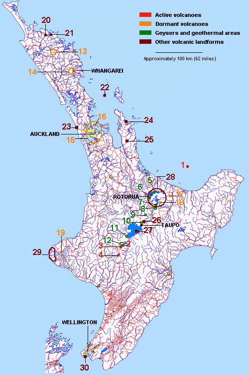
REGION: BAY OF PLENTY
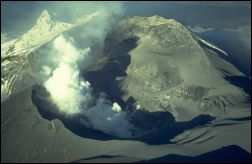
White Island: This is the most continuously active of New Zealand's volcanoes. It is located in the Bay of Plenty, 50 km (approx. 30 miles) from the coast. The island rises over 300 m (1000 ') above sea level but 70% of the whole structure is under the water, making it New Zealand's largest volcano. The continuous volcanic activity on the island includes boiling springs, mud pools, and steam and gas release. This is puncuated by periods of small to medium eruptions, as in 1998 when ash was received as far as Rotorua. Several tourism companies operate helicopters and launches from Rotorua and Whakatane. Caution: White Island is an active volcano. Hazards exist at all times. Do not venture on or close to the island without appropriately experienced and qualified guides.
TONGARIRO NATIONAL PARK
Mt Tongariro: Tongariro National park was created to protect the land encompassed by the three great volcanoes Tongariro, Ngaruhoe and Ruapehu. On Tongariro current volcanic activity is limited to geothermal features such as warm ground, steam and gas emissions, and hot springs. The most active (in deed of of New Zealand's most active) area is Ketetahi Hot Springs. The steam plume is usually easily visible from quite a long way, highways 46 and 47 in particular. They can be approached easily by a 2 hour walk (one way) from the Ketetahi carpark. However visitors are asked to maintain the springs' tapu, or sacredness, by not visiting them. Good views can be enjoyed from the track. The other active geothermal area on Tongariro is Red Crater, with some warm ground and steam release. The access to Red Crater, although not difficult, involves a 3 hour walk (one way) from Mangatepopo carpark on mountain terrain. It should be attempted by suitably experienced and equipped parties only. Visit Whakapapa Village Visitor Centre for further information before setting out.
Mt Ngaruhoe: This volcano erupted last in 1975. For several years after that a steam plume was usually rising from the crater, but in more recent times it has disappeared. Access to the crater involves a 3-4 hour walk (one way) from Mangatepopo carpark, up steep slopes of loose rock debris. It should be attempted by suitably experienced and equipped parties only. Remember that Ngaruhoe is an active volcano: the crater should be approched with care, and any sign of activity should be seen as potential danger. Visit Whakapapa Village Visitor Centre for further information before setting out.
Mt Ruapehu: An active eruption phase took place in 1995-1996, producing mostly ash and lahars. Ash spread as far as Gisborne and Rotorua, while some of the lahars flew down the Whakapapa skifield. The crater lake was emptied by the eruptions, and is still in a re-filling phase. Many interesting volcanic features such as old lava flows, lahar mounds and silica springs can be seen on or around the mountain. The crater area is a very interesting destination. It is a vast plateau, above 2500m (8200'), which includes, apart from Crater Lake, several peaks and a glacier. It can be reached by a 2-3 hour walk (one way) from the top of the chairlifts. The going is not difficult although route finding may be tricky, especially when visibility is not optimal. This is a high altitude alpine area, and this walk should be attempted by suitably experienced and equipped parties only. Visit Whakapapa Village Visitor Centre for further information before setting out.
- A recommended list of my own publications or media:
Comments
No comment available for this document
Ratings
Not yet rated
Rate it
X Close
Related documents Quick look
Below: the latest documents in
![]()
Open this category in Headlines for full navigation options and access to all categories and documents.
You can also use the navigation links located here in the right column.
×

