The Southern Alps: General Presentation
Introduction to the main characters of the longest and highest mountain range in New Zealand.
Document created 20 July 2003, last updated 21 July 2003

General character
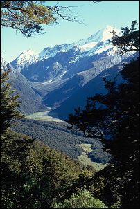
The Southern Alps are the longest and highest mountain range of New Zealand. They extend 550 km (340 miles) in a somewhat north-east to south-west orientation across the greatest length of the South Island, from the Blenheim area in the North to the Hollyford Valley (Key Summit) in the south. They include all New Zealand summits of over 3000 metres (9842'), all of which bar one (Mt Aspiring) are located in the Mt Cook area.
Origin
New Zealand lies over a zone of contact between the Pacific and Australian tectonic plates. In the South Island the contact runs overland and forms the Alpine Fault. Since the Fault was activated 25 million years ago the plates have mostly been sliding past each other, with a total displacement of 480 km (300 miles). But in the last 7 million years and to this day the Pacific Plate has also been overriding the Australian Plate along this line of contact, the subsequent compression giving rise to the Southern Alps.
Located in the transition zone between plain and mountain, the Alpine Fault forms a very sharp western boundary to the Southern Alps. In Westland the highest summits and main divide are within 15-25 km (9-15 miles) of the Alpine Fault.
The rate of uplift is high, exceeding 10 mm/year (0.4 in.) close to the Alpine Fault. Total uplift of Pacific Plate rocks over the whole period is estimated to be in excess of 20 km (12 miles), but because of very high erosion rates the range probably never exceeded its present altitude.
Read more about plate tectonics in New Zealand.
Regional units
Rock type, geomorphology, altitude, glaciation, help to identify 4 main regions or units within the Southern Alps:
The northern Southern Alps, comprising the mountains from Blenheim and the Wairau River (including Nelson Lakes National Park) to Lewis Pass. Although part of this unit, the Kaikoura Ranges are treated separately
The eastern Southern Alps, comprising all ranges east of the axial zone from Lewis Pass in the north to Lake Hawea
The axial Southern Alps, along the main divide, reaching its greatest heights from Arthur's Pass to Haast Pass
The western Southern Alps, west of the main divide south of Lewis Pass.
For more information please read other documents in this category and related categories (navigation links below).
Comments
No comment available for this document
Ratings
Not yet rated
Rate it
X Close
Related documents Quick look
Below: the latest documents in
![]()
Open this category in Headlines for full navigation options and access to all categories and documents.
You can also use the navigation links located here in the right column.
×
